Blog Image

SideScan

Mulige vrakrester funnet på sonarbilder

News Posted on Mon, June 25, 2012 22:33:30

Etter gjennomgang av flere sonar-filer fra området utenfor Hvasser viser det seg at det flere steder ligger spennende objekter som meget mulig kan være vrak-deler.

Det er bilder av objekter/konstruksjoner som tydelig ikke har oppstått naturlig, altså menneske-skapt.
Flere av objektene er garantert IKKE ting som det ville vært naturlig å finne ute på åpent vann.

Se noen av bildene her:


Searching for a President

News Posted on Wed, May 09, 2012 11:05:34

Background: On the last day of January 1936 the steam-ship President Christie hit the underwater rocks at “Tristeingrunnen” outside Hvasser.
The 177 ft. long ship was abandoned by the crew just a few minutes later.
Divers have tried to locate the wreck ever since, but so far….

Early 2012 a group of divers and survey personel are working as a team to locate the steel ship built back in 1872.


Shipwreck outside Horten, Norway

News Posted on Sun, January 01, 2012 22:17:32

I’ts been a while since we have published any new wreck images on this page, but here it comes!

While processing some sidescan data to create a mosaic a new undiscovered wreck was found. As far as we know this wreck have not been registered before now.

New sidescan surveys of the wreck will be done before next summer, no positive identification can be made until then.
Calculations from the sidescan data shows that the wreck is about 40 meters long.

The wreck is within air-diver depths, in protected waters, and are within easy access for recreational-divers.

Here are a couple of images of the wreck.

glenn@gasss-tech.com


SonarTRX Introduction

News Posted on Mon, July 25, 2011 22:32:31

The SonarTRX sidescan sonar processing software makes it easy to view and annotate sidescan recordings on a map, by using free 3D map viewers such as Google Earth or any other map-viewer capable of viewing kml files.

The latest versions of SonarTRX also has a built-in sonar data viewer that greatly simplify the process of locating features in your data. It also lets you define the associated time-intervals for each feature (i.e. “clips”) for easy retrieval.

For more advanced users, the geo-referenced images produced by SonarTRX can be imported to a variety of professional GIS and mapping programs for production of sidescan imagery of the entire survey area.

The software supports recordings from the most affordable sidescan sonars on the market, including Humminbird w/Side Imaging, Lowrance StructureScan, StarFish by Tritech, Imagenex YellowFin and SportScan, and other sonars supporting the XTF file format.

There are two versions of SonarTRX:

SonarTRX – Supports multiple sonar file formats

SonarTRX-SI – Supports Humminbird Side Imaging (SI) file format

For more details, please visit www.sonartrx.com


Panzer 2 – WW2 tank

News Posted on Wed, October 27, 2010 00:20:12

Rumors tell that there was a German WW2 tank sunk in one of the Norwegian inland-lakes. No rumor shall be forgotten without looking into it!

During the summer of 2006 we rigged a small RIB boat with a single sided 200KHz sidescan, and did some scans along the cliff in the sea where the rumors tell that there was a German tank missing during the first days of the German invasion of Norway.
This is a tank of similar type:

We did not have too much hope that we would make any discoveries at this site, as the site have been dived by several sport-divers during the years.
And so it was, we did not make any contacts during the day.

A couple of days later, during post processing of the sidescan data, we made a sensational discovery! We had located the missing German tank!

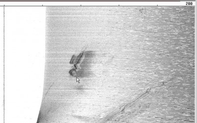
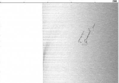
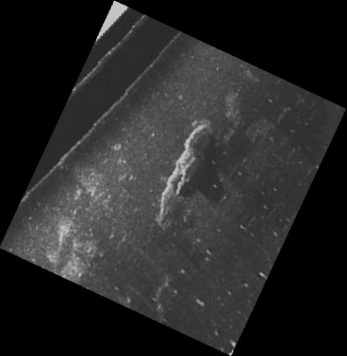
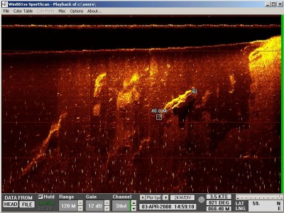
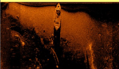
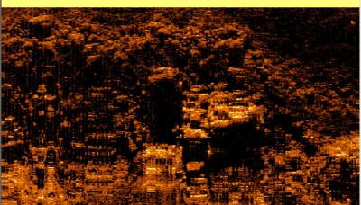
The tank can be seen at the bottom middle of the image. The tank is “facing” the viewer in the image.
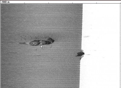
This is a small tank, and the image is not the best. But we can still see the gun barrel on the small tower, and the belts on the tank.
The location of the tank have not been revealed for the public.

glenn@gasss-tech.com


Wooden wreck at Minnesund, Norway

News Posted on Wed, October 27, 2010 00:06:16

This is another wreck close to Mjøsa and Minnesund, lying in shallow waters.
This waters are cold and the wood in the wrecks survive for decades (so it seems).

glenn@gasss-tech.com


Old wreck in Mjøsa, Norway

News Posted on Wed, October 27, 2010 00:01:23

Back in 2005 an old wreck was located in the lake Mjøsa, the largest inland-lake in Norway.

The discovery of the wreck was done while setting up and tuning the sidescan system.
The site have been reported and registered with the Norwegian Maritime Museum.
This lake was the main transportation route in these parts of Norway in early times, as the lenght of the lake is about 110Km running North-South from Lillehammer to Minnesund in Eidsvoll.

This is the best image we have of the wreck, as the wreck is almost completely burried in sand.

The wreck lays on the seafloor close to where the old steam-wheeler passes on its way to the shipyard at Minnesund. The site is not very deep, just a few meters during normal water height.

glenn@gasss-tech.com


Unidentified airplane

News Posted on Tue, October 26, 2010 23:34:32

Last year we did a few sidescans trying to locate some missing wrecks of bomber planes that went missing on missions in Norway during WW2.

We had some leads, and a “loose rumor” that one of the planes had been seen by a commercial diver back in the late 1960’s – early 1970’s.
This information was hard to confirm, and litte more info was known.

Using a 11 meter steel boat with a working platform in the aft, we headed out to do some sidescans and try to confirm the rumor about the plane.

This was what we got on the sidescan:

It might be a bit hard to se, but you can make out the contours of a plane in the zoom window.
Post processing of the collected sidescan data shows that this wery well might be the missing WW2 plane we hoped to locate. The measurements seems right based on the plane type, and the location is VERY near the actual crash site.

We have also recorded several “circular” shaped backscatter from the seafloor in the same area, witch might be craters made by the drop-mines that the bomber-plane dropped during its mission.
The objects on the site have not yet been confirmed by divers.

Update will follow when divers have visited the location.

glenn@gasss-tech.com


Next »